


Intelligent Automated Scanning Patterns for Pipelines & Facilities
Validated Leak Detection Accuracy — Explainable & Reproducible
AIRINS.ai 2D/3D Mapping
Overlays & AI Hotspot Localization
Follow-Up Ready
Report, Insight &
Quantification
Rapid, repeatable coverage across upstream, midstream and downstream assets
Applications
Pipelines
Rapid methane screening across long pipeline segments for routine LDAR inspection programs.
Aligned to LDAR workflows referenced in the EU Methane Regulation. MetScan enables repeatable pipeline screening, organizes mission history in AIRINS.ai (AAI), and exports inspection outputs to support follow-up actions and internal documentation.
Especially valuable where ground access is difficult (remote terrain, crossings, restricted or slow access).
Also well suited for post-maintenance checks, screening after construction or excavation near the pipeline, and rapid investigation of suspected leak events.


Facilities
Rapid methane screening across sites, pads, stations and plants with distributed leak sources.
Supports OGMP 2.0 workflows as a preliminary step before site-level top-down quantification, and LDAR workflows referenced in the EU Methane Regulation. MetScan helps pinpoint likely component- and source-level leak locations, prioritize repairs, and narrow gaps between bottom-up and top-down estimates.
MetScan + AIRINS.ai can also support offline, trial methane quantification workflows in collaboration with the Soarability team, providing emission-rate estimates (e.g., kg/h). This capability is not included as a default functionality in every deployment.
Especially valuable for large facilities, where repeated coverage helps teams focus follow-up on the most likely leak components and areas, in both routine screening and before/after maintenance checks.
Regulatory Alignment
Supports LDAR-style screening and data governance workflows referenced in these frameworks
LDAR-style screening & inspection documentation
Detection & follow-up for reconciliation workflows

Access control & data governance
Typical Workflow
Designed for long, linear pipeline assets where teams require routine LDAR-style screening along the pipeline.
The UAV follows the pipeline while MetScan performs an automated belt sweep to expand coverage to the left and right of the route, forming a continuous “belt” of geo-referenced methane measurements. By covering a wider cross-section around the pipeline on each mission, the screening reduces the chance of missing a gas cloud, even when wind direction varies.
At the same time, MetScan’s built-in imaging system records synchronized video along the mission, providing visual context for any elevated signals.
Belt Scan supports both waypoint flights and manual flights, enabling fast coverage and repeatable screening over the same pipeline segments, with data and video aligned for consistent review and follow-up.


Pipelines - Workflow
Designed for facility screening where potential leak sources are spread across sites, pads, and plant areas.
When UAVs cannot enter the site, Sector Scan allows the pilot to hover near the facility fenceline and run an automated sweep that generates geo-referenced methane measurements across the facility, providing broad coverage without flying inside.
When flying over the facility is allowed, Belt Scan creates belt-shaped coverage over defined areas inside the site. The UAV follows waypoint or manual paths while MetScan scans throughout the mission, building a continuous band of geo-referenced methane measurements. With the laser beam approaching the target area at an incident angle close to 90°, Belt Scan typically delivers higher data quality than fenceline-only Sector Scan.
Together, the two modes support repeatable, LDAR-style screening and help narrow suspected leaks down to specific units and components for handheld sniffer and OGI camera follow-up.


Facilities - Workflow
Output & Deliverables
Visualization
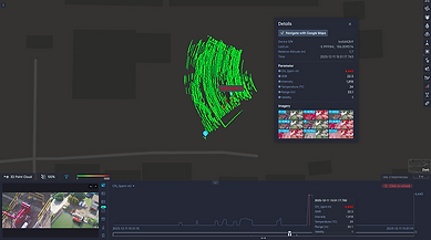
Try interacting with a small subset of AIRINS.ai’s visual functionalities below: click and drag to explore 2D/3D MetScan screening views, scroll to zoom, and use the icons to switch between Point Cloud, Grid, Ray and Interpolation heatmaps to see where methane signals concentrate.
AI-Assisted Report
AIRINS.ai turns each mission into a structured, actionable report. It summarizes flight coverage, screening mode, and provides a ranked list of suspected hotspots with coordinates and ppm·m levels. Each hotspot includes supporting imagery and an SNR-based confidence score.
Reports can be exported as PDF or editable DOCX for sharing and follow-up. The report also includes shareable Google Maps links to help field teams navigate directly to suspected hotspots found.
The report includes:
Cover page
Executive summary
Methods & QA/QC
Suspected hotspot details


Limitations & cautions
Glossary & units

Other Outputs
AIRINS.ai supports GIS-ready exports, including shapefiles (.shp) and structured data (.json) for integration into existing mapping and asset systems. For internal analysis, users can also export tabular data (.csv) to support review and recordkeeping across missions, and generate animated playback of screening results for briefings and discussions.
CSV
GeoJSON
Shapefile
Animations
Technology That Makes Every Inspection Count
Hardware

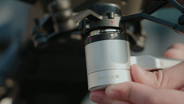
Diffuse-Reflection OP-TDLAS
MetScan uses a diffuse-reflection OP-TDLAS configuration to measure methane. A tunable laser beam is projected onto ground and facility surfaces, and the back-scattered light is analyzed at methane-specific wavelengths to derive stable, repeatable path-integrated measurements.
These measurements are geo-referenced and sent to AIRINS.ai (AAI) for visualization, analysis, and reporting.

Plug & Play UAV Integration
MetScan integrates seamlessly with DJI Matrice 350/400 via the DJI Payload SDK and SkyPort gimbal, running directly in the DJI Pilot App for safer, streamlined operation. No extra third-party app is required.
For non-DJI UAVs, a platform-agnostic integration kit provides onboard RTK-GNSS and IMU (gyroscopes and magnetometers), so MetScan can precisely determine its position, attitude, and laser footprint. The kit only requires power from the host UAV, keeping MetScan a largely self-contained payload for accurate methane screening across different platforms.

Data Output Frequency
MetScan streams data at up to 50 Hz, delivering ultra-dense methane sampling that captures even small plumes with confidence—a capability that is essential for precise emission quantification.

Dual-View Imaging System
MetScan records synchronized telephoto and wide-angle video on the same mission timeline, so each event can be reviewed with both close-up detail and wide-area context.
Context-Enriched Recording
Each clip is automatically tagged with flight time, methane concentration, SNR intensity, range, UAV position (lat/long), and relative altitude, keeping screening results traceable for later review and reporting.

Powerful Class 3R Laser
A Class 3R laser provides considerably higher optical power than typical Class 1 sources, supporting stronger return signals and a longer effective measurement distance.
As with any Class 3R laser, direct eye exposure should be avoided.

Computational Hub
Inside MetScan, a high-performance 8-core CPU delivering up to 6 TOPS of compute power handles real-time sensor signal and image processing, motion control, and data handling—all running on a powerful compact onboard computer.

Low False-Alarm and Missed-Alarm Rates
MetScan is engineered to achieve low false-alarm and missed-alarm rates through advanced laser and optics design, precise optics calibration, a proprietary false-alarm suppression algorithm, and dynamic signal-to-noise ratio (SNR) post-processing.


Thermal-Aware Exterior Design
MetScan’s silver, reflective housing is designed to minimize heat absorption during outdoor missions, reducing thermal load from sun exposure. This helps keep internal temperatures stable, protecting sensitive optics and electronics, supporting consistent measurement performance and longer component life.
Software

Multi-Region Data Hosting
Regional hosting in the EU, US, Singapore, and China to support data residency, compliance, and low-latency access.
Tailored User Experience
UI/UX designed specifically for methane screening workflows, with a clear and intuitive interface so teams can learn the system quickly and keep training effort low.

2.5D / 3D Reality Integration
Visualize MetScan screening data in 2.5D and 3D site models, from simple white buildings to detailed 3D meshes—for clear spatial context and precise leak localization.

One-Click Report Generation
Generate standardized methane screening reports with one click, without manual exporting or formatting.

AI Hotspot Identification
AI automatically flags methane hotspots and suspected leaks, guiding teams to the highest-risk locations first.

On-Premises Deployment
Available as an option: private, customer-controlled deployment on your own infrastructure for high-security environments.
Field Missions Gallery

MetScan payload mounted on a DJI Matrice 400 platform (single gimbal mount setup), ready for a methane screening mission.

MetScan mounted on a DJI Matrice 400 platform (single gimbal mount setup) during a live methane screening demo in Indonesia, with Halo Robotics pilots operating the mission.

This post-wildfire methane-screening mission assesses damage to the landfill-gas (LFG) collection system. Using AIRINS.ai, we generated an interpolated heatmap that highlights multiple methane hotspots. From the time-series graph we selected a high-concentration point (75,581 ppm·m); its position is marked on the heatmap with a pin. Imagery for the same point reveals disconnected pipelines—evidence of wildfire-related damage.
MetScan payload mounted on a DJI Matrice 400 platform (single gimbal mount setup), ready for a methane screening mission.
Frequently Asked Questions
1. What types of problems is MetScan + AIRINS.ai best suited to solve?
MetScan + AIRINS.ai is best suited for methane leak screening and localization at scale, helping teams efficiently cover large pipeline and facility areas, pinpoint likely leak locations, and prioritize follow-up verification and repair work. In addition, the solution can support offline, trial methane quantification workflows where dedicated flights and AIRINS.ai processing are used to estimate emission rates in collaboration with the Soarability team (rather than as a default functionality).
2. What applications does MetScan + AIRINS.ai support?
MetScan + AIRINS.ai supports two primary scenarios: pipelines and facilities screening, with different scanning modes optimized for each.
3. Is MetScan + AIRINS.ai only for the natural gas / oil & gas industry? Can it be used for other applications (e.g., landfills)?
MetScan + AIRINS.ai was engineered primarily for natural gas and oil & gas scenarios, where fast, repeatable methane screening and geo-referenced mapping are required. However, the same methane screening workflow may also be applicable to other methane-emitting sites - such as landfills (LFG - related operations) - depending on site conditions, operational constraints, and the type of outputs you need. If you share your site type, survey area, and objective (screening, localization, mapping / reporting), we can advise on fit and the recommended workflow.
4. Does MetScan + AIRINS.ai provide methane quantification?
Yes. In addition to methane leak screening and localization, MetScan + AIRINS.ai is technically capable of supporting methane quantification workflows. Operators can run targeted quantification flights and have the data processed offline in AIRINS.ai, combining MetScan’s path - integrated concentration measurements with flight geometry and wind information to estimate emission rates (e.g., kg/h).
At this stage, methane quantification is offered as a trial, offline workflow in collaboration with the Soarability team and is not included as a default functionality in every deployment. Quantification performance depends on flight design, wind conditions, terrain, and is intended to serve as a primary quantification option where conditions and regulations allow, and a strong complement to existing quant approaches in other scenarios.

Email:
Submit an Evaluation Request
To ensure a high-quality response, we evaluate each request based on use case, scale, and operational maturity. This helps us confirm fit and share the most relevant package details.
