1ppm NDIR CO2 Sensing & Mapping Products
Quantitative CO2 Detection at 1 ppm Resolution

Traditional Solutions
Poor Flexibility
Greenhouse gases have complex emission sources and traditional detection methods are not flexible in spotting all sources.
High Cost & Technical Bar
High budget on the device purchase and maintenance, greenhouse gases monitoring requires high accuracy and resolution.
Limited Time Granularity
The remote sensing satellite has a low time resolution.

Sniffer4D 1ppm CO2 solution provides a multi-dimensional detection system that maximizes the utilization of aerial and ground mobile monitoring, acquiring the 3D CO2 distribution information. As an innovative "Top-down" method to measure carbon emissions, our solution can help companies, governments and scientific institutions meet the needs for carbon emission detection, contributing to a net zero carbon world.


Oil & Gas Facility Detection
Facility Leak Detection (CH4 & CO2)
Scientific Research
GHG Vertical Profiling,
Meteorology Analysis
Environmental Protection
Source & Sink Locating,
Concentration Monitoring,
Fixed Monitoring Site Selection


1ppm NDIR CO2 Sensing & Mapping System
Compatible with a variety of UAVs, supporting up to 3 external modules for customized tasks with different configurations.
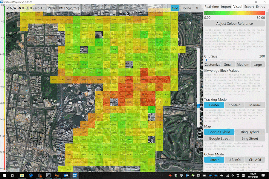
Advanced real-time data visualization and analytical software — Sniffer4D Mapper

Real-time intuitive & insightful information for decision-making

1ppm NDIR CO2 Sensing Module
Sniffer4D Mini2 base unit or Sniffer4D 1ppm TDLAS Methane Sensing & Mapping System required.
Response within Seconds
Non-dispersive Infrared (NDIR) detection method has the advantages of excellent gas selectivity & stability, quick response time, low cost, and high signal-to-noise-ratio, besides, it is less affected when exposed to hazardous gases.
When infrared light passes through the target gases, the gas molecules will absorb the infrared light with a specific wavelength. In this case, the CO2 concentration will be generated by the changes in light intensity, also known as the Lambert-Beer Law.
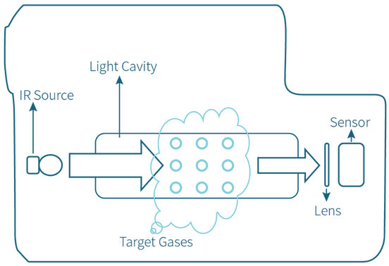
Detection method
Non-dispersive infrared (NDIR)
Range
0~2000ppm
Resolution
1ppm
(Static Noise Level <300ppb)
Conforming to
HJ 870-2017
Air Pump
Isokinetic Air Intake
UAV-based 1ppm NDIR CO2 Monitoring Series
Flexibly integrated on mobile platforms such as UAVs and robot dogs, a single device can simultaneously meet the needs of airborne and ground-based mobile GHG monitoring, making it easy to build a 3D monitoring network.


More Choices for Different Work Scenarios
1ppm NDIR CO2 Sensing & Mapping System supports working with 1ppm TDLAS Methane Sensing Module + Gas Sampling Module + Ultrasonic Wind Speed & Direction Sensing Module + Nuclear Radiation Sensing Module


One-one
Achieve Top-down Approach for Efficient Environmental Monitoring
Public Transport & Service Vehicles for Ground Measuring
With the long operating hours and random driving routes, the public transport & service vehicles-mounted solution can further reduce the cost of data collection, improving efficiency in locating the fugitive emissions sources scattered in time and space.

UAVs for Aerial Measuring
With the planned flight path and regional coverage, the UAV-based detection can achieve quick data collection from low altitudes covering a large area. Together with the visualized analytical software, the system brings real-time data display and visualization, as well as one-click result delivery for decision makers.


Create a 3D Monitoring Network
No limitation to terrain, achieving a solution for both aerial and ground GHG monitoring.

Continuous Spacial Monitoring
Support real-time concentration visualization from different altitudes.

Quantitative GHG Detection at 1ppm Resolution
Acquire ultra-high spatiotemporal environmental data in real time.
Sniffer4D System – One-stop Workflow
One-stop workflow allows users to easily finish data collection and work report in one mission.

Sniffer4D collects real-time data
4G real-time data transmission to the Cloud
Sniffer4D Mapper analyzes and visualizes the real-time data
Report & datasheet generation
Real-time concentration reading on DJI Pilot
Sniffer4D transmits data to DJI Pilot through PSDK connection
Real-time: Built-in 4G connectivity for real-time data transmission to one or multiple ends. Swarm supported.
* SIM card with traffic can be provided (cost separately).
Offline: Support SD auto recording (with GNSS-fixed) for post-mission analysis.
Supports Private Deployment to Third-party Platforms
* Contact Soarability to activate access
Sniffer4D hardware supports real-time data outputting to user-specified platforms through the MQTT protocol.
Sniffer4D Mapper software also supports outputting the decoded data (json format) to a designated IP address through UDP.
One-stop Workflow
One-stop workflow allows users to easily finish data collection and work report in one mission.